new book of lectures USA Новик Н,А.... new book of lectures USA Новик Н,А... Учебное пособие по дисциплинам Страноведение иЛингвострановедение
 Скачать 3.6 Mb. Скачать 3.6 Mb.
|

|
УО «БЕЛОРУССКИЙ ГОСУДАРСТВЕННЫЙ ЭКОНОМИЧЕСКИЙ УНИВЕРСИТЕТ» Н.А. Новик COUNTRY STUDIES: U.S.A. Course Pack Страноведение: США Курс лекций на английском языке Минск: 2014 Рецензенты: Рекомендовано кафедрой профессионально ориентированной английской речи и кафедрой межкультурной экономической коммуникации БГЭУ Новик Н.А. Страноведение: США = Country Studies: U.S.A. Курс лекций на английском языке / Н.А.Новик. - Минск: БГЭУ, 2014. – 251 с. Предлагаемый вниманию читателей курс лекций представляет собой учебное пособие по дисциплинам «Страноведение» и «Лингвострановедение» и «Культура страны изучаемого языка». В нем приводятся интересные, полезные и новейшие сведения о прошлом и настоящем Соединенных Штатов, культуре американцев, национальной политике, экономике, языке, вкладе иммигрантов в формирование американского государства и менталитета, т.д. Тексты информативны, сопровождаются словарем, кратким содержанием и ключевыми вопросами по теме. В каждую тему включена дополнительная информация, которая может быть использована на семинарских занятиях. При подготовке издания использованы оригинальные источники информации - в т.ч. книги, периодические издания и Интернет. В конце пособия приводятся тесты для контроля над пониманием услышанного в ходе лекций. Пособие предназначено для студентов, изучающих межкультурную коммуникацию, для студентов лингвистических вузов и лицеев, преподавателей, переводчиков, персонала туристических фирм, деловых людей, туристов и просто для тех, кто изучает английский язык. Contents Preface……………………………………………………………………………….4 Lecture 1. U.S. geography……………………………………………………………5 Lecture 2. History of the United States. Part 1. From colonization to revolution……………………………………… ……………………………….…..22 Lecture 2. History of the United States. Part 2. From westward expansion to the rise of imperialism…………………………..……………………………………………46 Lecture 2. History of the United States. Part 3. The U.S. in the 20th and 21st centuries……………………………………………………………………………..68 Lecture 3. American regionalism and the U.S. national capital………….…..……...92 Lecture 4. Federal government of the United States……………………….………112 Lecture 5. Economy of the United States…………………………………………..132 Lecture 6. U.S.A. -- nation of immigrants…….……………...…………………….154 Lecture 7. Culture of the United States…………………………………………….180 Lecture 8. American English……………………………………………………….207 Lecture 9. U.S. Education ………………………………………………………….235 References…………..………………………………………….…………………..250 PREFACE This course of lectures was designed to introduce the students majoring in intercultural communication to the world of U.S.A. studies. It incorporates the study of geography, economy, history, politics, literature, art, culture, education, American stereotype, population growth and structure and American English among other fields. Within modern memory people all over the planet have become remarkably conscious of the U.S.A. No wonder, the U.S. dollar is still one of the most convertible currencies. Even remote villagers know about this land “from sea to shining sea,” about California and the White House. “When America sneezes, the world gets a cold,” they say. So, the subject of these lectures is the U.S.A. or America. A key goal is to stimulate the students’ curiosity about the U.S.A. While reading this pack the students will become better informed and more experienced in understanding American culture and people. And understanding of cultural difference leads to an ability to communicate across difference, even if we don’t share the same beliefs, values, and objectives, etc. This course of lectures entails studying a complex and balanced picture of the U.S.A., identifying good and evil in the country’s social, political, and cultural life. The lectures show that the U.S. is more diverse than Hollywood westerns, Fourth-of-July bravado, United Fruit, and MTV would lead foreigners to believe. The course brings together ideas, concepts and facts from a wide variety of sources. Structurally, it is divided into nine lectures; each lecture offers the following four tools: First, a statement of the major themes to be found in the lecture; Second, a list of key words and proper names; Third, a structured text complemented by a wealth of additional information under the headline Interesting to know; Fourth, a summary of key points with a series of discussion questions; Fifths, small tests on comprehension of the material in each lecture. A list of references or sources is given at the end of the course pack. Hopefully, with the knowledge improved and expanded by this course, University graduates will have the expertise necessary to gain employment in the field of their major. LECTURE 1 GEOGRAPHY AND CULTURAL REGIONS OF THE U.S.A. This lecture will describe the land, physical features, and climate of the United States of America, and cover the following items:
Key Words and Proper Names: adjacent, arid (semi-arid), as of 2013 U.S. Census Bureau estimates, contiguous, converge, county, cultural identity, drainage, drawl, extant political entities, extraction, fossil fuel, freight, gorge, homogenizing influence, intermixing of cultures, level off regional differences, metro area, offshore rig, parish, precipitation, patois, pronounced peculiarities, resentment, reverence for the past, startling, statehood, thrift, tolerance, township, tributary, urban sprawl; Native American tribes;the Appalachian Mountains, the Adirondacks, the Cordilleran system, the Great Plains, the Interior Highlands, the Interior Plains, the Ozark Plateau, the Intermontane Plateaus, the Laurentian Highlands, the Rocky Mountains; the Great Lakes (Superior, Huron, Michigan, Ontario, and Erie), the St. Lawrence River, the Mississippi-Missouri rivers; the Colorado Desert, the Great Basin, the Mojave Desert, the Sonoran Desert, Sunbelt and Frostbelt; William Faulkner, Flannery O'Connor, Carson McCullers, Katherine Anne Porter, Robert Penn Warren, Eudora Welty, Tennessee Williams, Thomas Wolfe. The United States of America is a constitutional federal republic, it comprises 50 states and one federal district, and has several territories in the Caribbean and Pacific. To call the country as America is not absolutely correct. It is called as the United States, the U.S., the U.S.A., the U. S. of A., America, the States, or (poetically) Columbiadepending on a degree of formality In 1507, German cartographer Martin Waldseemüller made a world map on which he named the lands of the Western Hemisphere as "America" after Amerigo Vespucci, Italian explorer and cartographer. The country's modern name was first used in the Declaration of Independence, as the "unanimous Declaration of the 13 united States of America" adopted by the "Representatives of the united States of America" on July 4, 1776. The current name was finalized on November 15, 1777, when the Second Continental Congress adopted the Articles of Confederation, they state, "The Stile (name) of this Confederacy shall be 'The United States of America." The United States of America is the third largest country in the world after Russia and Canada with an area of 9,826,630 (9.8) sq km. The estimated U.S. population as of July 2014 was 318,662,000 people including an approximate 11.2 million illegal immigrants. So, in size of population it is also the third in the world behind China and India. The US political geography: The U.S. has the longest undefended ground border in the world with Canada and also shares a long ground border with Mexico. The country is divided into three distinct sections: a) the continental United States also known as the lower 48; b) Alaska, which is physically connected only to Canada, c) and the archipelago of Hawaii in the central Pacific Ocean. 49 states (all except Hawaii) lie on the North American continent; and 48 of them (all except Alaska) are contiguous and form the continental United States. Fig.1. 50 American states 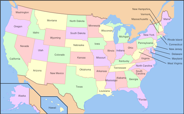 The state’s names are: Alabama, Alaska, Arizona, Arkansas, California, Colorado, Connecticut, Delaware, Florida, Georgia, Hawaii, Idaho, Illinois, Indiana, Iowa, Kansas, Kentucky, Louisiana, Maine, Maryland, Massachusetts, Michigan, Minnesota, Mississippi, Missouri, Montana, Nebraska, Nevada, NewHampshire, NewJersey, NewMexico, NewYork, NorthCarolina, NorthDakota, Ohio, Oklahoma, Oregon, Pennsylvania, Rhode Island, South Carolina, South Dakota, Tennessee, Texas, Utah, Vermont, Virginia, Washington, West Virginia, Wisconsin, Wyoming. As said above, the U.S. also holds several other territories, districts and possessions, first of all, the federal district called the District of Columbia, which is the nation’s capital, and several overseas areas, the most significant of which are Puerto Rico, American Samoa, Guam, Northern Mariana Islands, and the United States Virgin Islands. The U.S. Navy has held one military base called Guantanamo at an occupied portion of Guantanamo Bay on Cuba since 1898. The 50 U.S. states vary widely in size and population (Fig.2). The largest states in area are Alaska with an area of 1.7 ml sq km, followed by Texas, and California. The smallest state is Rhode Island, with an area of 4,002 sq km. The state with the largest population is California (35.8 ml people), followed by Texas, and New York. Only a bit more than 500,000 people live in Wyoming, which is also the least populous state. New Jersey, on the other hand, is the most densely populated state. Fig.2. The U.S. population density 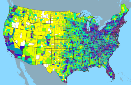 Interesting to know: State names speak to the circumstances of their creation. We may find: British names. Southern states on the Atlantic coast originated as British colonies named after British monarchs: Georgia, the Carolinas, Virginia, and Maryland. Some northeastern states, also former British colonies, take their names from places in the British Isles: New Hampshire, New Jersey, and New York. Native American names. Many states' names are those of Native American tribes or are from Native American languages: Nebraska, Kansas, Massachusetts, Hawaii, Connecticut, Missouri, Idaho, Iowa, Wisconsin, Illinois, Minnesota, the Dakotas, Mississippi, Texas, Utah, and others. Spanish names. Many states in the southeast and southwest have Spanish names, because they are on territories previously controlled by Spain or Mexico. They include Colorado, New Mexico, Florida, California and Nevada. French names. Because it was previously a French colony, Louisiana is named after the Louis XIV (King of France at the time). Washington, D.C., or the District of Columbia (also known as the Nation's Capital; the District; and, historically, the Federal City) is the capital city and administrative district of the U.S.A. Washington, D.C. is a part of the Baltimore-Washington Metropolitan Area, which includes parts of Maryland, Virginia, and West Virginia. It should not be confused with the U.S. state of Washington, located in the Pacific Northwest. The District of Columbia is a federal district. As specified by the U.S. Constitution, the District is ruled by the U.S. Congress, though it is unrepresented in that body. The population of the District of Columbia is more than 5 mln people. The centers of all three branches of the U.S. federal government are situated in Washington, D.C., as well as the headquarters of most federal agencies. Washington also serves as the headquarters for the World Bank, the International Monetary Fund, and the Organization of American States, and other international (and national) institutions. Washington is also the site of numerous national landmarks, museums, and is a popular destination for tourists. Largest cities: The U.S. has dozens of major cities, including several important global cities such as New York City, Los Angeles, and Chicago. The figures expressed below are for populations within 10 city limits (as of 2013 U.S. Census Bureau estimates).
Extensive areas of urban sprawl exist in larger metropolitan areas such as Los Angeles, California; Chicago, Illinois; and New York City. The U.S. politics: The states are generally divided into smaller administrative regions, including counties, cities and townships, with the exception of Louisiana, where counties are called parishes, and incorporate cities, villages, towns. Altogether, there are an estimated 85,000 extant political entities in the U.S. including counties, municipalities, townships, school districts, and special districts. The U.S. politics is represented by 50 state governments plus the government of the District of Columbia, and further down the ladder are still smaller units that govern counties, cities, towns, boroughs and villages. Like the national government, state governments have three branches: executive, legislative, and judicial; these are roughly equivalent in function and scope to their national counterparts. The chief executive of a state is the governor, elected by popular vote typically for a four-year term (although in a few states the term is two years). All states have a bicameral legislature, the upper house is usually called the Senate and the lower house is called the House of Representatives, the House of Delegates, or the General Assembly, except for Nebraska, which has a unicameral legislature. There are three general types of city government: the mayor-council, the commission, and the council-manager. These are the pure forms; many cities have developed a combination of two or three of them. Almost all city governments have some kind of central council, elected by the voters, an executive officer or mayor, assisted by various department heads, to manage the city’s affairs, a judge as well as a sheriff to provide law enforcement services. |