Географическая Карта Моделирования Бизнес процесса. Гео карта Google esrth. Kmlсправочник
 Скачать 7.61 Mb. Скачать 7.61 Mb.
|

|
Description Defines a virtual camera that is associated with any element derived from Feature. The LookAt element positions the "camera" in relation to the object that is being viewed. In Google Earth, the view "flies to" this LookAt viewpoint when the user double-clicks an item in the Places panel or double-clicks an icon in the 3D viewer. Elements Specific to LookAt Longitude of the point the camera is looking at. Angular distance in degrees, relative to the Prime Meridian. Values west of the Meridian range from −180 to 0 degrees. Values east of the Meridian range from 0 to 180 degrees. Latitude of the point the camera is looking at. Degrees north or south of the Equator (0 degrees). Values range from −90 degrees to 90 degrees. Distance from the earth's surface, in meters. Interpreted according to the LookAt's altitude mode. Direction (that is, North, South, East, West), in degrees. Default=0 (North). (See diagram below.) Values range from 0 to 360 degrees. Angle between the direction of the LookAt position and the normal to the surface of the earth. (See diagram below.) Values range from 0 to 90 degrees. Values for Distance in meters from the point specified by Specifies how the clampToGround - (default) Indicates to ignore the relativeToGround - Interprets the absolute - Interprets the A KML extension in the Google extension namespace, allowing altitudes relative to the sea floor. Values are: relativeToSeaFloor - Interprets the clampToSeaFloor - The This diagram illustrates the 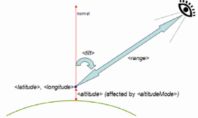 This diagram illustrates the 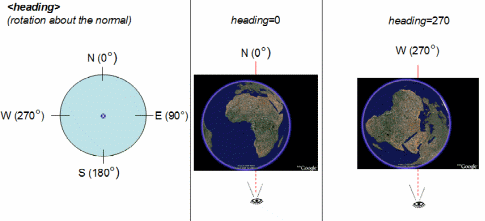 xmlns:gx="http://www.google.com/kml/ext/2.2"> Extends <AbstractView> Contained By Any element derived from <Feature> Syntax ... Description A 3D object described in a COLLADA file (referenced in the tag). COLLADA files have a .dae file extension. Models are created in their own coordinate space and then located, positioned, and scaled in Google Earth. See the "Topics in KML" page on Models for more detail. Google Earth supports the COLLADA common profile, with the following exceptions: Google Earth supports only triangles and lines as primitive types. The maximum number of triangles allowed is 21845. Google Earth does not support animation or skinning. Google Earth does not support external geometry references. Elements Specific to Model Specifies how the clampToGround - (default) Indicates to ignore the relativeToGround - Interprets the absolute - Interprets the A KML extension in the Google extension namespace, allowing altitudes relative to the sea floor. Values are: relativeToSeaFloor - Interprets the clampToSeaFloor - The Specifies the exact coordinates of the Model's origin in latitude, longitude, and altitude. Latitude and longitude measurements are standard lat-lon projection with WGS84 datum. Altitude is distance above the earth's surface, in meters, and is interpreted according to Describes rotation of a 3D model's coordinate system to position the object in Google Earth. See diagrams below. |