Географическая Карта Моделирования Бизнес процесса. Гео карта Google esrth. Kmlсправочник
 Скачать 7.61 Mb. Скачать 7.61 Mb.
|

|
Rotations are applied to a Model in the following order: Rotation about the z axis (normal to the Earth's surface). A value of 0 (the default) equals North. A positive rotation is clockwise around the z axis and specified in degrees from 0 to 360. Rotation about the x axis. A positive rotation is clockwise around the x axis and specified in degrees from 0 to 180. Rotation about the y axis. A positive rotation is clockwise around the y axis and specified in degrees from 0 to 180. 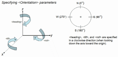 This diagram illustrates the typical orientation of a model's axes: 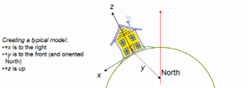 Scales a model along the x, y, and z axes in the model's coordinate space. Specifies the file to load and optional refresh parameters. See . Specifies 0 or more Specifies the texture file to be fetched by Google Earth. This reference can be a relative reference to an image file within the .kmz archive, or it can be an absolute reference to the file (for example, a URL). Is the path specified for the texture file in the Collada .dae file. In Google Earth, if this mapping is not supplied, the following rules are used to locate the textures referenced in the Collada (.dae) file: No path: If the texture name does not include a path, Google Earth looks for the texture in the same directory as the .dae file that references it. Relative path: If the texture name includes a relative path (for example, ../images/mytexture.jpg), Google Earth interprets the path as being relative to the .dae file that references it. Absolute path: If the texture name is an absolute path (c:\mytexture.jpg) or a network path (for example, http://myserver.com/mytexture.jpg), Google Earth looks for the file in the specified location, regardless of where the .dae file is located. Example Extends Contained By Syntax Description A container for zero or more geometry primitives associated with the same feature. Note: The Elements Specific to MultiGeometry 0 or more Example -122.4425587930444,37.80666418607323,0 -122.4428379594768,37.80663578323093,0 -122.4425509770566,37.80662588061205,0 -122.4428340530617,37.8065999493009,0 Extends Contained By
Syntax Description A multi-track element is used to combine multiple track elements into a single conceptual unit. For example, suppose you collect GPS data for a day's bike ride that includes several rest stops and a stop for lunch. Because of the interruptions in time, one bike ride might appear as four different tracks when the times and positions are plotted. Grouping these Elements Specific to gx:MultiTrack Specifies how altitude components in the clampToGround - (default) Indicates to ignore an altitude specification (for example, in the relativeToGround - Sets the altitude of the element relative to the actual ground elevation of a particular location. For example, if the ground elevation of a location is exactly at sea level and the altitude for a point is set to 9 meters, then the elevation for the icon of a point placemark elevation is 9 meters with this mode. However, if the same coordinate is set over a location where the ground elevation is 10 meters above sea level, then the elevation of the coordinate is 19 meters. absolute - Sets the altitude of the coordinate relative to sea level, regardless of the actual elevation of the terrain beneath the element. For example, if you set the altitude of a coordinate to 10 meters with an absolute altitude mode, the icon of a point placemark will appear to be at ground level if the terrain beneath is also 10 meters above sea level. If the terrain is 3 meters above sea level, the placemark will appear elevated above the terrain by 7 meters. A KML extension in the Google extension namespace, allowing altitudes relative to the sea floor. Values are: relativeToSeaFloor - Interprets the altitude as a value in meters above the sea floor. If the point is above land rather than sea, the altitude will be interpreted as being above the ground. clampToSeaFloor - The altitude specification is ignored, and the point will be positioned on the sea floor. If the point is on land rather than at sea, the point will be positioned on the ground. Boolean value. If the multi-track contains multiple Contains Syntax ... ... ... ... Description References a KML file or KMZ archive on a local or remote network. Use the element to specify the location of the KML file. Within that element, you can define the refresh options for updating the file, based on time and camera change. NetworkLinks can be used in combination with Regions to handle very large datasets efficiently. Elements Specific to NetworkLink Boolean value. A value of 0 leaves the visibility of features within the control of the Google Earth user. Set the value to 1 to reset the visibility of features each time the NetworkLink is refreshed. For example, suppose a Placemark within the linked KML file has Boolean value. A value of 1 causes Google Earth to fly to the view of the LookAt or Camera in the NetworkLinkControl (if it exists). If the NetworkLinkControl does not contain an AbstractView element, Google Earth flies to the LookAt or Camera element in the Feature child within the (required) Tip: To display the top-level Folder or Document within a Network Link in the List View, assign an ID to the Folder or Document. Without this ID, only the child object names are displayed in the List View. Example ... Extends <Feature> Contained By any element derived from <Container> Syntax Description Controls the behavior of files fetched by a Elements Specific to NetworkLinkControl Specified in seconds, Specified in seconds, Use this element to append a string to the URL query on the next refresh of the network link. You can use this data in your script to provide more intelligent handling on the server side, including version querying and conditional file delivery. You can deliver a pop-up message, such as usage guidelines for your network link. The message appears when the network link is first loaded into Google Earth, or when it is changed in the network link control. You can control the name of the network link from the server, so that changes made to the name on the client side are overridden by the server. You can control the description of the network link from the server, so that changes made to the description on the client side are overridden by the server. You can control the snippet for the network link from the server, so that changes made to the snippet on the client side are overridden by the server. You can specify a date/time at which the link should be refreshed. This specification takes effect only if the With Example Extends This is a direct child of the Contained By See Also <Object> Syntax Object id="ID" targetId="NCName" --> Object> --> Description This is an abstract base class and cannot be used directly in a KML file. It provides the id attribute, which allows unique identification of a KML element, and the targetId attribute, which is used to reference objects that have already been loaded into Google Earth. The id attribute must be assigned if the Syntax Overlay id="ID" --> ... ... ... |