Пособие по обучению практике устной и письменной речи (начальный этап) на английском языке Под ред. О. В. Серкиной
 Скачать 17.03 Mb. Скачать 17.03 Mb.
|

Как вести себя в лондонском автобусе?Сразу после входа необходимо оплатить проезд: в центре Лондона билет для взрослого стоит £2. За проезд заплатить можно водителю или воспользоваться сканером для билетов (ticket reader) если у вас уже есть билет. На некоторых маршрутах нельзя оплатить проезд наличными в самом автобусе. На всех остановках таких маршрутов установлены автоматы по продаже билетов, в которых вам необходимо приобрести билет. Если вы не оплатите поездку или у вас будет неверный билет, вас оштрафуют. Если вам необходимо выйти, нажмите на кнопку специального звонка. Это не стоит делать, если кто-либо уже позвонил до вас. В 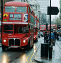 се автобусы оснащены двусторонней связью с водителем, а во многих установлены внутренние видеокамеры. Курение в Лондонских автобусах запрещено. се автобусы оснащены двусторонней связью с водителем, а во многих установлены внутренние видеокамеры. Курение в Лондонских автобусах запрещено. Ночные автобусные маршруты. В центре Лондона действует много ночных автобусных маршрутов, связывающих Трафальгарскую площадь, театры, кинотеатры и места отдыха и развлечений. На таких маршрутах все остановки считаются остановками "по требованию". Поэтому для посадки в него надо "голосовать", а для выхода из него - позвонить в звонок. Стоимость проезда на ночных маршрутах такая же, как и днем, но детские билеты не действительны - оплата производится по взрослому тарифу. Лондонское метро Лондонское метро - первая подземная железная дорога в мире. Первая линия была пущена в 1863 году, а уже в 1906 по линиям метро пошли поезда на электрической тяге. Сейчас Лондонское метро или "труба" – The Tube - как его здесь называют - одно из крупнейших в мире: 275 станций на 12 линиях. Метро работает с 5:30 до 24 часов по будням и субботам и с 7:00 до 23:00 по воскресеньям. Утренний час пик заканчивается примерно в 9:30, вечерний продолжается с 16 до 19 часов. Оплата проезда в метро Лондона.Все станции метро поделены на 6 зон: 1 зона - это центр Лондона, 6 зона - окраины. Стоимость билета зависит от количества проезжаемых зон. Одна поездка внутри первой зоны стоит £1.50 для взрослых и £0.60 для детей. Если взрослый путешествует с действующим билетом, то он может провезти собой в метро до четырех детей младше 11 лет бесплатно. Если вы планируете совершить несколько поездок, то выгоднее приобрести Travelcard. Они бывают сроком на год, месяц, неделю или день. Поездка на один день в пиковый сезон стоит £6.60. Карты Travelcard действительны для оплаты поездок как в метро, так и в автобусах и на некоторых пригородных поездах. Билеты можно приобрести на всех станциях метро, в кассах или автоматах. В случае, если касса закрыта, а в автомате нет нужного вам проездного, то можно купить простой билет, а, приехав на станцию назначения, обменять его на необходимый вам, доплатив разницу в цене. Штраф за безбилетный проезд составляет £20. Unit 3. The Place I live in. My Country.  A land flowing with milk and honey. A land flowing with milk and honey.Bible: Exodus, III, 8. Nature is a house to dwell in. Charles Lamb Recommended grammar: Modals. BUILDING-UP YOUR VOCABULARY 3.1. Read the information about Russia, find all the geographical names on the map and be ready to give presentation on Russia in class. 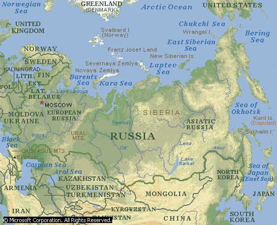 Russia or Russian Federation (Russian Rossiyskaya Federatsiya), is an independent republic in Eastern Europe and Northern Asia, the world’s largest country by area. In general, Russia’s climate is similar to that of Canada. Much of the land lies north of the 50th parallel of latitude and far from the moderating influences of oceans. Like Canada, although colder and with greater temperature extremes in many places, most of Russia has a harsh continental climate. Although climate, and to some degree soils, limit the country’s agricultural wealth, mineral wealth is considerable: Russia’s mineral resources are unmatched by any other country. Russia’s borders measure more than 20,100 km (12,500 miles). In the north Russia is bounded by extensions of the Arctic Ocean: the Barents, Kara, Laptev, East Siberian, and Chukchi seas. In the east the country is bounded by the Pacific Ocean and several of its extensions: the Bering Strait (which separates Russia from Alaska), the Bering Sea, the Sea of Okhotsk, and the Sea of Japan (East Sea). In the extreme southeast Russia abuts the northeastern tip of North Korea. In the south it is bounded by China, Mongolia, Kazakhstan, the Caspian Sea, Azerbaijan, Georgia, and the Black Sea. In the southwest it is bounded by the Ukraine, and in the west by Belarus, Latvia, Estonia, the Gulf of Finland, and Finland. In the extreme northwest, Russia is bounded by Norway. Lithuania and Poland border Kaliningrad Oblast, a Russian exclave on the Baltic Sea. The capital and largest city is Moscow. Administratively until 2005, Russia included 89 subjects of the Federation: 21 republics; 6 territories known as krays; 10 national areas called okrugs; 49 regions, or oblasts; 1 autonomous oblast; and 2 cities with federal status. In 2004 there was initiated a process of consolidation of national areas with bigger subjects. So far the people of 5 okrugs have supported this process. In both total area and geographic extent Russia is the largest country in the world. With an area of 17,075,200 sq km (6,592,800 sq miles), Russia constitutes more than one-ninth of the world’s land area and nearly twice the area of the United States or China. From north to south Russia extends more than 4,000 km (2,400 miles) from Arctic islands in the Barents Sea to the southern border along the Caucasus mountains. From the eastern coast of the Baltic Sea to Big Diomede Island (Ratmanov Island) in the Bering Strait, Russia’s maximum east-west extent is almost 10,000 km (6,200 miles), a distance encompassing 11 time zones and spanning nearly half the circumference of the Earth. Russia stretches across parts of two continents, Europe and Asia, with the Urals and The Ural River marking the boundary between them. Russia’s principal islands lie in the Arctic and Pacific oceans and their extensions. Farthest north, in the Arctic Ocean, is Franz Josef Land, an archipelago consisting of about 100 small islands. The other main Arctic islands, from west to east, include the two islands of Novaya Zemlya, Vaygach Island, the group of islands called Severnaya Zemlya, the New Siberian Islands, and Wrangel Island. Between these major islands lie numerous small islands and island chains. In the Pacific ocean are the Kuril Islands, which extend southwest in an arc from the Kamchatka peninsula to the main islands of Japan. Russia occupies and administers all the Kuril Islands, although ownership of the southernmost islands is disputed with Japan. The Pacific also includes the large island of Sakhalin, which separates the Seas of Okhotsk and Japan. Russia contains complex geologic structures and surface formations. Very simply, however, the landmass consists of vast plains in the west and north, and a discontinuous belt of mountains and plateaus in the south and east. The upland and mountainous regions include most of Siberia and extend to the Pacific. Russia can be divided into several broad geographic regions. From east to west they are the Great European Plain; the Ural Mountains; the mountain systems and ranges along much of Russia’s southern border; and the lowlands and uplands of Siberia, including the West Siberian Plain, the Central Siberian Plateau, and the mountain ranges of northeastern Siberia. 1 3.2. Put the words in each line in the box in order according to their size (the smallest first, the largest last). In each list there is one word that does not belong with the others. Cross it out. . forest tree copse beach wood 2. road peak footpath track lane 3. mountain hillock shore hill mountain range 4. gorge plain waterfall hollow valley 5. gulf ridge inlet bay cove 6. cliff brook river estuary stream 7. city continent tributary county country 8 3.3. Put the words and expressions in the box into their correct category in the tables. Some can be included in more than one category. . pond puddle ocean cape lake
3.4. Complete the following passage with the necessary words from the previous activities and some geographical names. Use a map of Russia. The total _____ of Russia is approximately 17 million square kilometers. The _____ is about 150 million. Russia ______ one eighth of the whole land of the earth. The Northern _______ of Russia is formed by the ______ ocean and its seas. In the West Russia is bounded by _____, Finland, Estonia, Latvia, Lithuania, Belorussia and the _____. In the South it borders on Turkey, _____, Azerbaijan, Kazakhstan, ______, Mongolia and Korea. In the East it shares borders with the _____ and Japan. The shores of Russia are washed by 12 _____ of the Atlantic, Pacific and Arctic oceans. The greater part of the territory is a vast _____ with low mountains and long rivers. The biggest plains are the Great ______ Plain in Eastern Europe and the West Siberian Plain in the Asiatic part of the country. The biggest mountain ranges are the Urals and the _______. The Urals form the natural border between Europe and ______. The highest _________chain, the Caucasus, is situated between the Caspian and ________ seas. There are a lot of rivers and lakes in this country. The Volga and the Ural are the longest _______ in the European part of Russia. The longest rivers in the _______ part are the Lena, the Yenisei and the Ob, which _____ into the Arctic Ocean. Lake ______ is the largest fresh-water lake in Asia and Europe and the deepest in the world. The climate in Russia is varied. It is mainly _______ and continental. Russia is rich in ______ : coal, iron, oil, gas, ferrous and non-ferrous metals and many others. ( 3.5. Match each country on the left with the name on the right by which it is also known. a) Holland Eire (b) Iran The Netherlands (c) Myanmar Ulster (d) Sri Lanka Persia (e) The Republic of Ireland Ceylon (f) Northern Ireland Burma ( 3.6. Explain the difference between the two names in each of the following pairs. a) England and (Great) Britain (b) (Great) Britain and the United Kingdom (c) (Great) Britain and the British Isles (d) Europe and Continental Europe (e) The Middle East and the Far East (f) India and the Indian Subcontinent (g) America and North America (h) South America and Latin America (i) The Arctic and the Antarctic (j) Australia and Australasia (k) South Africa and Southern Africa ( 3.7. Which countries are referred to by the following expressions? a) The European Union Countries (d) The West Indies (b) The (British) Commonwealth (e) The Gulf States (c) The NATO Countries (f) The Third World ( 3.8. a )Which countries are sometimes referred to by the following colloquial expressions? What do you know about these countries? Try to find some interesting facts about them and make a short presentation in class. b) Has Russia ever had any nicknames? a) The States (b) Down Under (c) The Land of the Rising Sun (d) The Emerald Isle (e) The Celestial W 3.9. Look at the report below and fill in the gaps with one of the words or expressions from the previous activities. In some cases, more than one answer is possible. You may need to change some of the word forms. e began our journey in the capital, Triguengos, a (1) _________ conurbation of almost ten million. It is not a pretty place; heavily (2) ________, with huge factories belching out black fumes, and miles of (3) ________ as housing estates and shopping centres spread out from the (4) _________ centre for miles. It was a relief to leave. As soon as we got into the coutryside, things improved considerably. The climate is dry and it is difficult to grow anything, but thanks to (5) _______, which helps bring water in from the Rio Cauto (the huge river with its (6) ______ high up in the snow-covered (7) _______ of the Sierra Maestra (8) __________), the land is fertile enough to grow the sugar cane on which much of the economy is based. We saw few people, however, as many have moved to the towns and cities to look for more profitable work. It is largely due to this rural (9) ________ that sugar-cane industry is suffering. Further south and we entered the Hoguin (10) _______, with mountains rising high above us on both sides. The land here drops sharply to the sea and the slow-moving waters of the Rio Cauto give way to (11) _____ which tumble over cliffs, and small, fast-moving (12) ________ which are not even wide enough to take a boat. At this point, the road we were traveling along became a (13) _______ which was only just wide enough for our vehicle, and then an unpaved (14) ________ which almost shook the vehicle to pieces. And then suddenly, the Pacific (15) _________ was in front of us. Our destination was the town of Santiago de Gibara, built on a (16) _______ sticking out into the blue waters. The countryside here undulates gently, with low (17) _____ covered in rich tropical jungle. The open (18) ______ surrounding the (19) _______ of the Rio Cauto as it reaches the ocean is rich and (20) _________, ideal for growing the tobacco plants, which need a lot of warm and damp soil. That night I lay in my cheap hotel, listening to the waves gently lapping the (21) ________, and when eventually fell asleep, I dreamt of the people who first inhabited this (22) __________ almost two thousand years before. T 3.10. a) Scan the text to find the names of the climatic zones of Russia. b) Read the text again and pick up the main features of the climatic zones in Russia. he broad zones of natural vegetation and soils correspond closely to the country’s climate zones. Summers are too cool for trees in the far north, where tundra vegetation of mosses, lichens, and low shrubs grows instead. Permafrost, or permanently frozen subsoil, is found throughout this region. There is a polar desert zone on several Arctic islands to the north of the tundra zone; the vegetation in this zone consists of a limited number of moss and lichen groupings scattered in patches. Russia’s forests, located mostly in Siberia, cover more than two-fifths of the country’s total territory (1/4 of the world’s total forested area). The forest zone has two distinct areas: a large, mainly coniferous forest, or taiga, lies in the north, and a much smaller area of mixed forest lies in the south. The taiga occupies two-fifths of European Russia and extends across the Urals to cover much of Siberia. Much of the taiga also has permafrost. This vast zone is made up primarily of coniferous trees, but birch, poplar, aspen, willow and other deciduous trees also grow there. The taiga contains the world’s largest coniferous forest, representing about one-third of the world’s softwood timber. Larch, a deciduous conifer, becomes dominant throughout much of the Central Siberian Plateau and the mountains of eastern Siberia. Large areas of taiga zone are devoid of trees, particularly where the soil is poorly drained. In these areas marsh grasses and bushes form the vegetative cover. The taiga contains infertile, acidic soils known as ultisols, or podzols. A  mixed forest, containing both coniferous and broad-leaved deciduous trees, occupies the central portion of the Great European Plain between Saint Petersburg and the Ukrainian border. The mixed forest is dominated by coniferous evergreen trees in the north and broad-leaved trees in the south. The principal broad-leaved species are oak, beech, maple, and hornbeam. Gray-brown soils are found in the mixed forest zone. mixed forest, containing both coniferous and broad-leaved deciduous trees, occupies the central portion of the Great European Plain between Saint Petersburg and the Ukrainian border. The mixed forest is dominated by coniferous evergreen trees in the north and broad-leaved trees in the south. The principal broad-leaved species are oak, beech, maple, and hornbeam. Gray-brown soils are found in the mixed forest zone. To the south, the mixed forest transitions through a narrow zone of forest-steppe and then passes into the zone of a true steppe. The natural vegetation of a forest-steppe is grassland with scattered groves of trees. At present much of Russia’s forest-steppe is under cultivation. The natural vegetation of a true steppe consists of a mixture of grasses with only a few stunted trees in sheltered valleys. Both the forest-steppe and the steppe have fertile soils and together form a region known as the chernozem, or black-earth, belt; this is the agricultural heartland of Russia. Soils in the chernozem belt are high in humus content and have a balance of minerals that is suitable for most crops. The forest-steppe has a better moisture supply than the steppe during the growing season, and consequently it is the best agricultural area of Russia. The chestnut and brown soils of the southern steppe are not as rich in humus as the chernozems to the north, but they are high in mineral content and can be productive with adequate moisture. 3.11. a) Scan the text to pick up the names of animals common for different climatic zones of Russia. Fill out the chart below. b) Do any of the animals belong to the following classes: rodents, reptiles, carnivores, herbivores, or predators?
Animal life is abundant and varied throughout Russia. The tundra, which spans the Arctic and northern Pacific coasts and encompasses Russia’s offshore Arctic islands, is home to polar bears, seals, walruses, arctic foxes, lemmings, reindeer, and arctic hares. Birdlife includes white partridges, snowy owls, gulls, and loons. Geese, swans, and ducks migrate into the region during summer, a time when huge swarms of mosquitoes, gnats, and other insects emerge. South of the tundra, the taiga is a habitat for elks, brown bears, lynx, sables, and a variety of forest birds, including owls and nightingales. Swamps in this zone have been stocked with muskrats from Canada. Muskrats and squirrels are now the main source of pelts trapped in the wild. The broad-leaved forests of the Great European and West Siberian plains contain boars, deer, wolves, foxes, and minks. There are also a variety of birds, snakes, lizards, and tortoises. The forests in the southern part of far eastern Russia are known for the Siberian tiger - the largest cat in the world - as well as leopards, bears, and deer. The steppe primarily contains rodents such as marmots and hamsters, but there are also a few species of hoofed animals, including antelope. The main beasts of prey are steppe polecats and Tatar foxes. Bird life includes cranes and eagles. The Caucasus region is particularly abundant in wildlife, including mountain goats, chamois, Caucasian deer, wild boars, porcupines, leopards, hyenas, jackals, squirrels, and bears. There is also a variety of game fowl, including black grouses, turkey hens, and stone partridges. Reptiles and amphibians are also numerous in the Caucasus region. Many animal species are threatened or endangered, including the snow leopard and the Siberian tiger. A great number of threatened or endangered species are found in far eastern Russia, including Chinese egrets, red-crowned cranes, and Nordmann’s greenshanks. 3.12. Study the following words describing weather and pick up those which can be used to describe the current weather in your town. Use a dictionary to check out the pronunciation. General expressions: What kind (sort) of weather is it? / What is the weather like? How’s the weather? The weather may be: fine/ jolly/ marvelous/ lovely/ glorious, bright/ sunny, soft/ mild, bad/ awful/ filthy/ nasty/ wretched/ beastly/ dreary/ dull, misty/ foggy, damp/ raw /moist, chilly, dry, sultry/ hot/ stuffy, frosty, stormy, windy, variable/ broken/ unsettled A: What oppressive/ sultry weather! B: Yes, isn’t it stifling/ heavy/ close (informal)? A: Isn’t it humid today? B: Yes, horribly muggy/ clammy (informal)! It looks as if we are going to have snow. The weather is improving. I hope it’ll keep fine. Warm weather: What lovely weather! After the thunderstorm the air is remarkably fresh. It’s unbearably hot today. How stifling the air is! (It’s suffocating!) The heat is abating/ decreasing. A: It’s hot, isn’t it? B: Yes, it’s boiling/sweltering/ roasting! (Informal) Cold weather: It freezes. / It’s freezing. It’s perishing cold. / It’s precious cold. / The cold searched my marrow. / I am chilled to the marrow. / The very marrow in my bones is cold. A: Bit chilly today, isn’t it? B: Yes, it’s freezing/ nippy ((informal), isn’t it? It’s below freezing point. The air was stingingly cold, but not at freezing point. It’s a sharp frost, isn’t it? The air is frosty. I feel chilly /cold. It’s uncommonly cold after the rain. The sky: cirrus (wispy) clouds (= light clouds that form high up in the sky) stratus (= layered) clouds, cumulus (= heaped) clouds, nimbus (= rain-bearing) clouds The sky is clouded/ overcast. The sky was suddenly overcast with low, black clouds. The clouds are dispersing and the sun is appearing again. The wind:  A cold biting wind almost swept me off my feet. A cold biting wind almost swept me off my feet. There isn’t a breath of air. The wind has abated. Types of wind: a breeze - a slight, moderate wind a wind a strong wind a gale - a very strong wind a hurricane - a very strong wind, more than 100 km per hour, can be dangerous a blizzard - a blinding snow-storm a squall - a sudden violent wind, often during rain or snow storms a monsoon – a wind that blow south from Asia in January and north from Australia in July a tornado – a violent storm with very strong winds which move in a circle a gust of wind - a sudden violent rush of wind A: It’s a bit windy today! B: Yes, it’s really blowy/ breezy (informal), isn’t it? Thunder. Lightning: It thunders. There is a thunderstorm hanging about/ coming/approaching. That’s a thunder-cloud over there. A flash of lightning lit the sky. Peals/ rolls of thunder were heard. It lightens. Dazzling flashes of lightning were followed by a clap/ burst of thunder. The storm has spent itself. The Rain: These clouds omen (promise) rain. The rain has set in. It keeps on raining. It’s a pelting rain. It’s beastly wet. It rained now and then. A drizzling piercing rain continued all day. The rain was accompanied by a strong wind and hail. The rain’s leaving off. A: What a downpour/ deluge! B: Yes, it’s chucking it down/ it’s pouring (informal). When there is no rain for a long time, it is drought. The snow: The snow is falling thick. We had a heavy snowfall / a heavy fall of snow yesterday. It’s a rather snowy winter. Last year we had a green winter (mild winter with little snow). Snow-drifts surrounded us from all sides. 1 3.13. Find collocations for these words. Use a dictionary. . ______________ 4. ________________ ______________ climate the winds of ________________ ______________ ________________ 2. _____________ 5. _______________ prevailing _____________ a frosty _______________ _____________ _______________ 3. _____________ 6. _______________ to cloud _____________ a hail of _______________ _____________ _______________ 1 3.14. Read the text and find the words in the text which mean the following. . average 6. rays from the sun 2. dry 7. make less extreme 3. height above sea level 8. situated very far from the sea 4. distance from the equator 9. differing weather conditions at 5. rain and snow different times of the year S 3.15. Read the text and single out the main features of each season. Are they true for your region? chemes for dividing the Earth into climatic regions are based on a combination of indices of mean annual temperature, mean monthly temperature, annual precipitation totals and seasonality. The climate of a place is affected by several factors. Latitude affects the amount of solar radiation received, with the greatest in equatorial` regions and the least in polar regions. Elevation affects both temperature and precipitation; mountainous areas are generally cooler and wetter. Location close to the sea or to large bodies of water moderates temperature; continental areas are generally more arid and more affected by extremes of temperature. |