методичка2010 (1). Методические указания для курсантов ii курса спо, обучающихся по специальности 26. 01. 01 Эксплуатация внутренних водных путей для аудиторной и самостоятельной работы
 Скачать 2.17 Mb. Скачать 2.17 Mb.
|

|
Text 5. Weather ship A weather ship was a ship stationed in the ocean as a platform for surface and upper air meteorological measurements for use in weather forecasting. It was also meant to aid in search and rescue operations and to support transatlantic flights. The establishment of weather ships proved to be so useful during World War II that the International Civil Aviation Organization (ICAO) established a global network of 13 weather ships in 1948. Of the 12 left in operation in 1996, nine were located in the northern Atlantic Ocean while three were located in the northern Pacific Ocean. The agreement of the weather ships ended in 1990. Weather ship observations proved to be helpful in wind and wave studies, as they did not avoid weather systems like merchant ships tended to and were considered a valuable resource. The last weather ship was MS Polarfront, known as weather station M at 66°N, 02°E, run by the Norwegian Meteorological Institute. MS Polarfront was removed from service January 1, 2010. Since the 1960s this role has been largely superseded by satellites, long range aircraft and weather buoys. Weather observations from ships continue from thousands of voluntary merchant vessels in routine commercial operation. Exercise 48. Выпишите выделенные слова и переведите на русский язык. Exercise 49. Почитайте текст и составьте десять вопросов по содержанию. Exercise 50. Перескажите текст, используя выделенные слова. Exercise 51. Напишите сочинение на тему ‘A day at meteorological station’ Appendix I. Supplementary reading. Text 1. Personal weather station A personal weather station is a set of weather measuring instruments operated by a private individual, club, association, or business (where obtaining and distributing weather data is not a part of the entity's business operation). Personal weather stations have become more advanced and can include many different sensors to measure weather conditions. These sensors can vary between models but most measure wind speed, wind direction, outdoor and indoor temperatures, outdoor and indoor humidity, barometric pressure, rainfall, and UV or solar radiation. Other available sensors can measure soil moisture, soil temperature, and leaf wetness. The quality, number of instruments, and placement of personal weather stations can vary widely, making the determination of which stations collect accurate, meaningful, and comparable data difficult. There are a comprehensive number of retail weather stations available. Personal weather stations typically involve a digital console that provides readouts of the data being collected. These consoles may interface to a personal computer where data can be displayed, stored, and uploaded to websites or data ingestion/distribution systems. Open-source weather stations are available that are designed to be fully customizable by users. Personal weather stations may be operated solely for the enjoyment and education of the owner, while some owners share their results with others. They do this by manually compiling data and distributing it, distributing data over the Internet, or sharing data via amateur radio. The Citizen Weather Observer Program (CWOP) is a service which facilitates the sharing of information from personal weather stations. This data is submitted through use of software, a personal computer, and internet connection (or amateur radio) and are utilized by groups such as the National Weather Service (NWS) when generating forecast models. Each weather station submitting data to CWOP will also have an individual Web page that depicts the data submitted by that station. The Weather Underground Internet site is another popular destination for the submittal and sharing of data with others around the world. As with CWOP, each station submitting data to Weather Underground has a unique Web page displaying their submitted data. The UK Met Office's Weather Observations Website (WOW) also allows such data to be shared and displayed. Text 2. Rivers. A river is a natural flowing watercourse, usually freshwater, flowing towards an ocean, sea, lake or another river. In some cases, a river flows into the ground and becomes dry at the end of its course without reaching another body of water. Small rivers can be referred to using names such as stream, creek, brook, rivulet, and rill. There are no official definitions for the generic term river as applied to geographic features, although in some countries or communities a stream is defined by its size. Many names for small rivers are specific to geographic location; examples are "run" in some parts of the United States, "burn" in Scotland and northeast England, and "beck" in northern England. Sometimes a river is defined as being larger than a creek, but not always: the language is vague. Rivers are part of the hydrological cycle. Water generally collects in a river from precipitation through a drainage basin from surface runoff and other sources such as groundwater recharge, springs, and the release of stored water in natural ice and snowpacks (e.g., from glaciers). Rivers and streams are often considered major features within a landscape; however, they actually only cover around 0.1% of the land on Earth. They are made more obvious and significant to humans since many human cities and civilizations are built around the freshwater supplied by rivers and streams. Most of the major cities of the world are situated on the banks of rivers, as they are, or were, used as a source of water, for obtaining food, for transport, as borders, as a defensive measure, as a source of hydropower to drive machinery, for bathing, and as a means of disposing of waste. In the preindustrial era larger rivers were a major obstruction to the movement of people, goods, and armies across them. Towns often developed at the few locations they could be crossed. Many major cities such as London are located at the lowest point at which a river could be bridged. Potamology is the scientific study of rivers, while limnology is the study of inland waters in general. Text 3. Lakes. A lake is an area filled with water, localized in a basin, surrounded by land, and set apart from any river or other outlet that serves to feed or drain the lake. Lakes lie on land and are not part of the ocean, although, like the much larger oceans, they do form part of the Earth's water cycle. Lakes are distinct from lagoons, which are generally coastal parts of the ocean. Lakes are typically larger and deeper than ponds, which also lie on land, though there are no official or scientific definitions. Lakes can be contrasted with rivers or streams, which usually flow in a channel on land. Most lakes are fed and drained by rivers and streams. Natural lakes are generally found in mountainous areas, rift zones, and areas with ongoing glaciation. Other lakes are found in endorheic basins or along the courses of mature rivers, where a river channel has widened into a basin. Some parts of the world have many lakes formed by the chaotic drainage patterns left over from the last ice age. All lakes are temporary over long periods of time, as they will slowly fill in with sediments or spill out of the basin containing them. Many lakes are artificial and are constructed for industrial or agricultural use, for hydro-electric power generation or domestic water supply, for aesthetic or recreational purposes, or for other activities. In 1957, Hutchinson published a monograph titled A Treatise on Limnology, which is regarded as a landmark discussion and classification of all major lake types, their origin, morphometric characteristics, and distribution. Hutchinson presented in his publication a comprehensive analysis of the origin of lakes and proposed what is a widely accepted classification of lakes according to their origin. This classification recognizes 11 major lake types that are divided into 76 subtypes. The 11 major lake types: tectonic lakes, volcanic lakes, glacial lakes, fluvial lakes, solution lakes, landslide lakes, Aeolian lakes, shoreline lakes, organic lakes, anthropogenic lakes, meteorite (extraterrestrial impact) lakes. Text 4. Reservoirs. A reservoir is most commonly an enlarged natural or artificial lake created using a dam to store fresh water. Reservoirs can be created in a number of ways, including controlling a watercourse that drains an existing body of water, interrupting a watercourse to form an embayment within it, through excavation, or building any number of retaining walls or levees. Defined as a storage space for fluids, reservoirs may hold water or gasses, including hydrocarbons. Tank reservoirs store these in ground-level, elevated, or buried tanks. Tank reservoirs for water are also called cisterns. Most underground reservoirs are used to store liquids, principally either water or petroleum, below ground. The limnology of reservoirs has many similarities to that of lakes of equivalent size. There are however significant differences. Many reservoirs experience considerable variations in level producing significant areas that are intermittently underwater or dried out. This greatly limits the productivity or the water margins and also limits the number of species able to survive in these conditions. Upland reservoirs tend to have a much shorter residence time than natural lakes and this can lead to more rapid cycling of nutrients through the water body so that they are more quickly lost to the system. This may be seen as a mismatch between water chemistry and water biology with a tendency for the biological component to be more oligotrophic than the chemistry would suggest. Conversely, lowland reservoirs drawing water from nutrient rich rivers, may show exaggerated eutrophic characteristics because the residence time in the reservoir is much greater than in the river and the biological systems have a much greater opportunity to utilize the available nutrients. Deep reservoirs with multiple level draw off towers can discharge deep cold water into the downstream river greatly reducing the size of any hypolimnion. This in turn can reduce the concentrations of phosphorus released during any annual mixing event and may therefore reduce productivity. The dams in front of reservoirs act as knickpoints-the energy of the water falling from them reduces and deposition is a result below the dams. Glossary: Unit 1: atmosphere – атмосфера organic life – органическая to proceed – развиваться interaction – взаимодействие indispensable – необходимый atmospheric gases – атмосферные газы oxygen – кислород nitrogen – азот water vapor – водяной пар carbon dioxide – углекислый газ ozone – озон aerobic organisms – аэробные организмы mineral nutrition – минеральное питание to absorb the harsh UV radiation of the Sun – впитывать агрессивное ультрафиолетовое излучение Солнца vitality of organisms – жизнеспособность организмов hydrosphere – гидросфера composition of atmospheric gases – смесь атмосферных газов biosphere – биосфера Unit 2: humidity – влажность gigro-meters – гигрометр psychrometers – психрометр air temperature – температура воздуха water vapor – водяной пар air humidity – влажность воздуха to fluctuate – переливаться daily and annual course – ежедневный и годовой ход diurnal course – суточный ход coastal areas – прибрежные территории yearly course – ежегодный ход moisture – влага moisture content of the air – содержание влаги в воздухе the earth surface – поверхность земли Unit 3: essential – необходимый solid – твердый liquid – жидкий gas – газ to tie together – связаны вместе climate system – климатическая система air – воздух clouds – облака the ocean – океан lake – озеро vegetation – произрастание snowpack – снежный покров glaciers – ледники water cycle – круговорот воды to evaporate – испарять water vapor – водяное испарение transportation – перенос infiltration – проникновение percolation – просачивание groundwater – подземные воды plant uptake – потребление растениями transpiration – испарение воды растительностью sublimation – переход из газообразного состояния в твердое, минуя жидкое и наоборот deposition – выпадение осадков Unite 4: groundwater – подземные воды rock – скала soil pore spaces – пространства в пористых почвах fractures of rock formations – разломы горных пород available fresh water – доступная свежая вода unit of rock – горная цепь unconsolidated deposit – рыхлое отложение aquifer – водоносный горизонт depth – глубина, бездна voids – пустоты to saturate with water – насыщать водой water table – уровень (горизонт) грунтовых вод springs – источники seeps – места просачивания воды или нефти из земли oases – оазис wetlands – водно-болотные угодья extraction wells – откачная скважина hydrogeology – гидрогеология hydrology – гидрология water flowing through shallow aquifers – вода протекающая через мелкие водоносные горизонты soil moisture – влажность грунта permafrost (frozen soil) – вечная мерзлота immobile water – неподвижная вода permeability – водопроницаемость bedrock – почвенный горизонт, основная порода geothermal – геотермальный oil formation – нефтяной пласт Unit 5: weather ship – метеорологическое судно meteorological measurements – метеорологические измерения weather forecasting – прогнозирование погоды to aid – оказывать помощь search and rescue operations – исследовательские и спасательные операции transatlantic flight – трансатлантический перелет establishment – основание (учреждение чего-либо) wind and wave studies – изучение ветра и волн to run by – обслуживаться (какой-либо организацией) to be superseded by satellites – быть вытесненными искусственными спутниками weather buoys – погодный буй Appendix 2. Неправильные глаголы английского языка 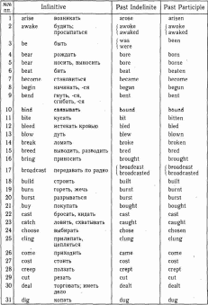 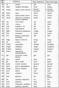  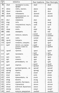 CONTENTS Цели и задачи курса ………………………………….…3 Unit 1. Atmosphere and life………………………………5 Unit 2. Air humidity……………………………………..11 Unit 3. The water cycle on earth………………………...21 Unit 4. Ground water…………………………………….26 Unit 5. Meteorogical instruments. Weather ships……….32 Appendix 1. Supplementary reading…………………….40 Appendix 2. Glossary……………………………………44 Appendix 3. Irregular verbs……………………………...47 |